

KILIMANJARO’S HISTORY
History of Mt. Kilimanjaro….Thanks to several primitive stone bowls found on the lower slopes of Kilimanjaro, we know that man has lived on or around the mountain since at least 1000BC. We also know that, over the last 500 years, the mountain has at various times been a navigational aid. This is for traders travelling between the interior and the coast, a magnet for Victorian explorers. A political pawn to trade between European superpowers who carve up East Africa. A battlefield for these same superpowers, and a potent symbol of independence. This is for those who wished to rid themselves of these colonial interlopers. Unfortunately, there is little information about the history of the mountain during the intervening two thousand five hundred years.
One of the stone bowls found in the region of Kilimanjaro
It’s a fair bet that Kilimanjaro’s first inhabitants, when they weren’t fashioning stone bowls out of the local terrain, would have spent much of their time hunting and gathering the local flora and fauna, Kilimanjaro being a fecund source of both.
Add to this its reputation as a reliable region both for fresh drinking water and materials – wood, stones, mud, vines etc – for building, and it seems reasonable to suppose that Kilimanjaro would have been a highly desirable location for primitive man, and would have played a central role in the lives of those who chose to take up residence on its slopes.
Unfortunately, those looking to piece together a comprehensive history of the first inhabitants of Kilimanjaro rather have their work cut out. There are no documents recording the life and times of the people who once lived on the mountain. This is not much in the way of any oral history that has gone down through the generations. Also, the stone bowls apart, little in the way of archaeological evidence from which to draw any inferences.
A QUICK LESSON IN GEOGRAPHY
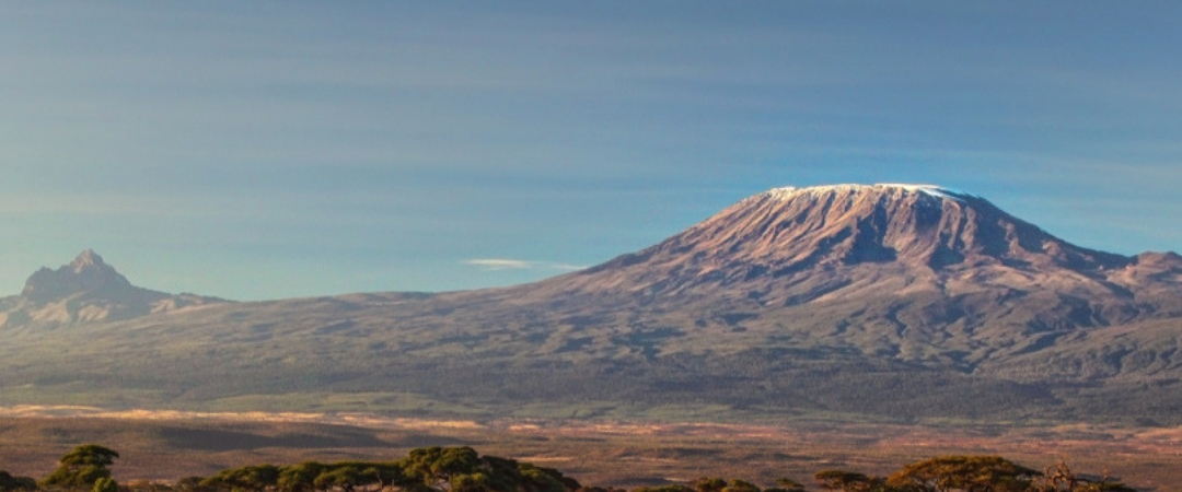
Located in the north of Tanzania virtually straddling the country’s border with Kenya, Kilimanjaro is the remnants of three volcanos, to the west Shira and Mawenzi on the east, sandwiching Kibo – the tallest of the three – in the centre. Geographically speaking, they believe its peaks to have been formed about three million years ago. This is during the formation of the Great Rift Valley . Now, highlighted by the flat plains which surround it, Kilimanjaro is the tallest stand-alone peak in the world. Its summit, known as Uhuru Peak (Uhuru meaning freedom in Swahili) stands at 5,895m.
While some believe it to be the European pronunciation of a KiChagga phrase. Meaning ‘we fail to climb it’, the name Kilimanjaro is commonly a mix. This is of the Swahili word Kilima, meaning mountain, and the KiChagga word Njaro, loosely translating as whiteness.
While eruptions over millions of years have reshaped its figure, volcanic activity has been on hold for over 200 years and its last major eruption is thought to have taken place around 360,000 years ago. Having said this, Kibo is still definitely dormant rather than extinct and sulphur can still be smelt as it’s emitted from fissure vents near the central ash pit.
Near the summit on the western slope sit the Northern Ice Field, which at one point, connecting to the Eastern and Southern Ice Fields formed a continuous glacial body atop Kilimanjaro. First examined in 1912, 11.4 square kilometres were glaciated, by 2011 the ice fields had separated and had reduced to a collective 1.76 kilometres, an 85% overall loss. This pattern of retreat is not anticipated to change and many have predicted all the ice on top of Mount Kilimanjaro to be gone by 2040 attributed to drier conditions and a warming climate.
THE HUMANS OF KILIMANJARO
At the start of the eleventh century, indigenous communities from across Africa arrived in northern Tanzania as part of a succession of migrations. Descendants of various Bantu tribes populated the southern and eastern slopes of Mount Kilimanjaro, Mount Meru and the surroundings of the town of Moshi, establishing themselves as a new populace, The Chagga people.
Now accounting for the third largest ethnic group in the country, the Chagga have remained Bantu-speakers, though their language has a number of dialects related to Kamba – spoken in northeast Kenya – and to other languages spoken in the east, such as Dabida and Pokomo.
Their agricultural methods
Thanks to their successful agricultural methods, including extensive irrigation systems, terracing and continuous organic fertilization methods, the Chagga have maintained relative wealth. While bananas are their staple, they cultivate various crops including yams, beans, and maize. Internationally,they know them for Arabica coffee, they export to American and European markets.
Over control of trade, as far back as the accounts go, Chagga chiefdoms were relentlessly at war with one another.
Hostility
After an initial period of welcoming missionaries, travelers, and foreign representatives as they did traders; in the 1880s, when the Chagga gradually lost their autonomy, hostility grew. In 1886, Germany and Britain divide their East African provinces of influence and Kilimanjaro was to the Germans.
When strong resistance to German control manifest itself, Sudanese and Zulu troops came in. By the 1890s, there was crushing of the Chagga. A handful of armed Germans successfully ruled a hundred thousand Chagga, giving cooperating chiefs more power than they could otherwise ever know and hanging those who resisted.
Religion
Eventually, warfare came to an end and churches got religious control over different parts of Kilimanjaro. Also, there was introducing schools and coffee-growing clinics. Thus, a Western religion, Western medicine, Western education, and a cash crop were all imposed on the Chagga.
Long distance trade became a European monopoly and coffee growing spread rapidly over the mountain as the colonial government passed from German hands into those of the British in 1916. Since 1961, Tanzania has been an independent nation but Arabica coffee remains a major cash crop on which it relies for foreign exchange.
The Chagga mythology
The fact it sits so high as a solitary mountain, suggests to local people it’s the product of supernatural activity and as a result, Chagga mythology has various explanations for the formation of Kilimanjaro.
One legend tells how a man named Tone provoked a god, Ruwa, to bring famine upon the land. When local people became angry, forcing him to flee, nobody would protect him but a solitary dweller who had the ability to turn stones into cattle. Though the dweller warned Tone never open the stable of the cattle he did not listen and the cattle escaped. With Tone in pursuit of the fleeing cattle, they produced hills to aid their escape, including Mawenzi and Kibo. Out of exhaustion, Tone finally collapsed on Kibo.
Kibo and Mawenzi
Another legend has it that Kibo and Mawenzi were good neighbors. This was until Mawenzi played a prank on Kibo, throwing away embers he had received as a gift from Kibo. Also claiming they had burned out. Kibo eventually got angry and beat Mawenzi badly. This explains why the mountain the reason behind Mawenzi’s name as ‘the Scarred’.
Other legends tell of ivory-filled elephant graves on the mountain, and of a cow named Rayli that produces miraculous fat from her tail glands. If a man tries to steal such a gland but is too slow, Rayli will blast a powerful snort to blow the thief down into the plain.
The Wakonyingo
Local tribesmen still believe that mountain dwarfs they call Wakonyingo live in caves beneath Kili’s slopes. The Wakonyingo have oversized heads and prey upon those who bring negative spirits to the mountain. The myth could be based on reality as there is evidence that pygmies once roamed the mountain.
The first European to reach the mountain was a missionary, Johannes Rebmann. He arrived in 1848, though the the first attempt to climb the mountain wasn’t for another 13 years. In 1861, Prussian officer Baron Karl Klaus von der Decken accompanied by English geologist R. Thornton attempted the first expedition to the summit, though due to harsh conditions, they got no farther than 8,200 feet.
Attempts
Though there were numerous attempts in the years, the first attempt with any real success did not come until 1887. This is when German geology professor Hans Meyer was at the lower edge of the ice cap on Kibo. Only to turn back due to being ill-equipped to traverse the ice on the upper slopes. The following year, Meyer planned another attempt. But the mission was abort. This was after he and his expedition partner, cartographer Oscar Baumann, were held hostage and ransom during the Abushiri Revolt.
Hans Meyer
Finally in October of 1889, Hans Meyer, Ludwig Purtscheller and local, Lauwo reached the summit Mount Kilimanjaro in October 1889. The success of the expedition was thanks to the establishment of several campsites with food supplies. This means multiple strikes on the summit were possible without needing to descend too far. After turning round close to the crater rim exhausted, on Purtscheller’s fortieth birthday. They reached the highest summit on the southern rim of the crater. Descending slightly, the team then made several other exploratory campaigns, on the mountain. One to the more technically challenging Mawenzi and one again up Kibo to enter and study the crater. In total, Meyer and Purtscheller spent 16 days above 15,000 feet (4,600 m) during their expedition.
This was the first recorded expedition to reach the summit. It is certainly possible that despite not recording them, locals were successful prior to this.